
by Peter Berg
This piece was originally published in Discovering Your Life-Place, written by Peter Berg, Planet Drum Books, copyright 1990.

Bioregions are their own countries with bottlers that reflect changes in natural continuities. To see how dissimilar these borders are from today s often straight-lined political boundaries, look at a vegetation and landform map that shows the contiguous “lower 48” states of the United States.
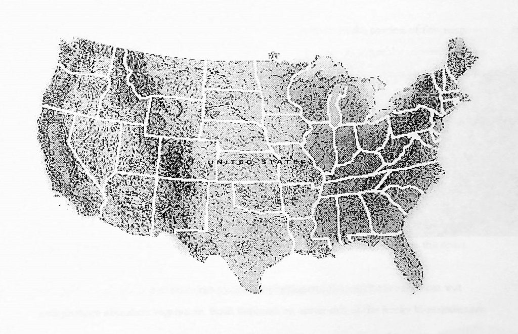
It is evident that there are strong differences between natural areas although almost none of them are recognized in geopolitical terms. For example, nearly all of the United States-Canada border west of the Great Lakes is a straight line that cleaves through territory that is exactly the same on both sides of the boundary between these two nations.
The states and provinces within both countries can be seen to usually have straight-lined borders as well, even though a straight line in natural geography is extremely rare. These politically-derived straight lines are taken to absurd lengths in some places. Kansas is a rectangle. So is Wyoming, one of the least flat or rectilinear terrains on the North American continent.
The differences between general physiographic characteristics in the portion of this map covered by the United States follow a distinct pattern (see page 7). From the eastern seaboard to the Mississippi River the climate is wetter, so more land area is coveted in vegetation than any other part of the country. West of the Mississippi, the Great Plains are progressively drier as they move into the rain shadow of the Rocky Mountains. This dry shadow occurs because the Rockies are so tall in comparison to the relatively flat terrain around them that they easily interrupt clouds passing eastward, forcing much rain and snow to precipitate before crossing over to the Great Plains. A similar situation exists west of the Rockies with the desert-like Great Basin which lies in the combined rain shadows of the Cascade and Sierra Nevada Ranges. Further west, heavy precipitation which the Cascades bring to the Pacific Ocean side of the mountains produces rain forests fed by storms that break on the coast.
The general pattern is that there are five major physiographic areas. Both coasts are wet and produce abundant vegetation. Both flat areas on either side of the Rocky Mountains are significantly drier. The snow-catching Rockies divide the continent and send rivers heading toward the east, west, north and south.
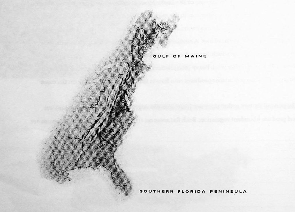
These great expanses of land are too large to constitute coherent bioregions. Even though they share the obvious characteristics which have been described, places within them are different from each other in important ways. For example, the wet eastern seaboard contains both the Gulf of Maine and the southern Florida peninsula bioregions. Except for relatively high rainfall in both places, the Gulf of Maine with its extreme seasonal changes and sub-zero winters is vastly unlike Florida with its evenly high year-round tropical temperatures.
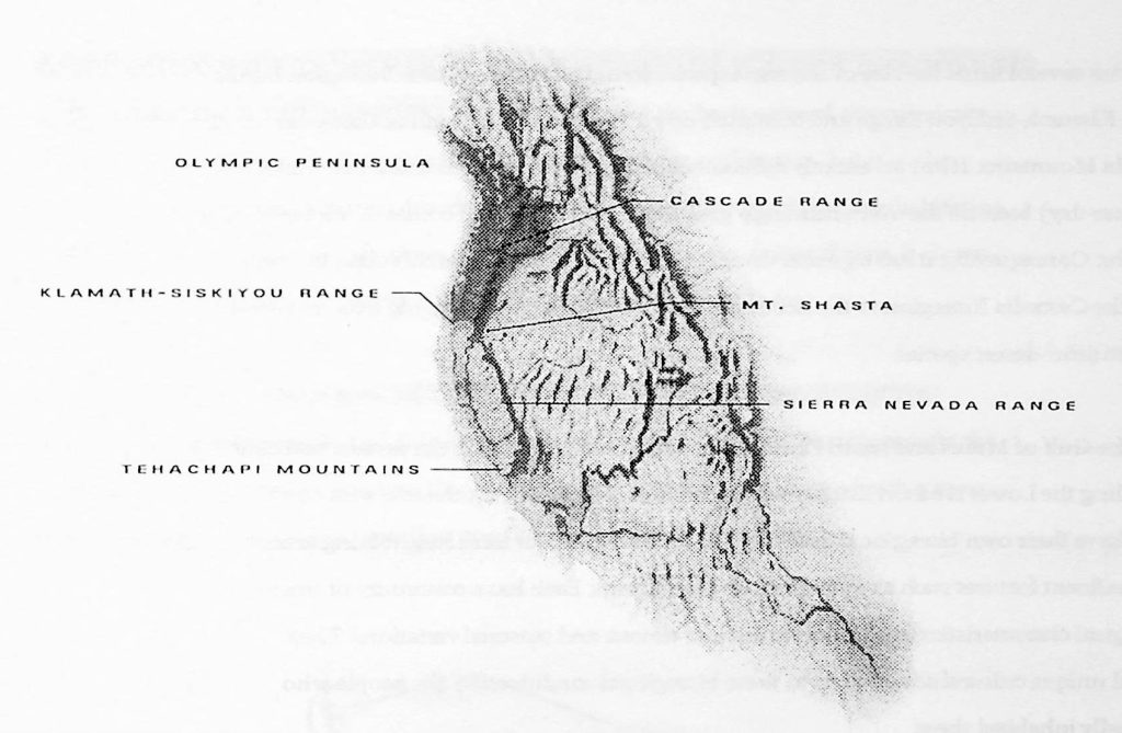
The west coast of the United States exhibits two different neighboring zones of wetness that underlie the differences between two major bioregions Cascadia and Shasta. Cascadia Bioregion is bounded by the volcanic Cascade Range and gets the greatest rainfall. The Olympic Peninsula can receive in excess of two hundred inches of rain a year and plants are often several times the size of the same species found elsewhere. Shasta Bioregion begins at the Klamath-Siskiyou Range and continues down to parallel the length of the Sierra Nevada Mountains. It has an entirely different climate termed Mediterranean (or winter-wet summer-dry) because the overwhelmingly greatest part of its rainfall comes in winter months Consequently, it has a greater diversity of habitats that reflects this climatic contrast than the Cascadia Bioregion to the north and many different plants ranging from redwood trees to semi-desert species.
Like the Gulf of Maine and south Florida, and other bioregions along the eastern seaboard including the Lower Hudson Estuary which contains New York City, the two west coast areas have their own bioregional qualities. They are all different from neighboring areas in significant features such as watersheds and landforms. Each has a continuity of unique geological characteristics in addition to distinct climate and seasonal variations. They all had unique cultural adaptations to these bioregional conditions by the people who originally inhabited them.

Peter Berg (1937-2011) founded the Planet Drum Foundation (planetdrum.org) in San Francisco in 1973. His creative work and activism spanned decades, ranging from script-writing while a member of the San Francisco Mime Troupe and writing manifestos for The Diggers in the 1960s to presenting at the UN World Environment Day conference on urban sustainability and the Ecocity World Summit in the 2000s. In recognizing the significance of the connection between society and ecology, Berg was a leading early thinker in the development of the bioregional movement. Further biographical information available at https://planet-drum.net.