The Cascadia Subduction Zone
The Cascadia Subduction Zone (CSZ) "megathrust" fault is a 1,000 km long dipping fault that stretches from Northern Vancouver Island to Cape Mendocino California. It separates the Juan de Fuca and North America plates. New Juan de Fuca plate is created offshore along the Juan de Fuca ridge. The Juan de Fuca plate moves toward, and eventually is shoved beneath, the continent (North American plate).

The Cascadia subduction zone (also referred to as the Cascadia fault) is a convergent plate boundary that stretches from northern Vancouver Island in Canada to Northern California in the United States. It is a very long, sloping subduction zone where the Explorer, Juan de Fuca, and Gorda plates move to the east and slide below the much larger mostly continental North American Plate. The zone varies in width and lies offshore beginning near Cape Mendocino Northern California, passing through Oregon and Washington, and terminating at about Vancouver Island in British Columbia.
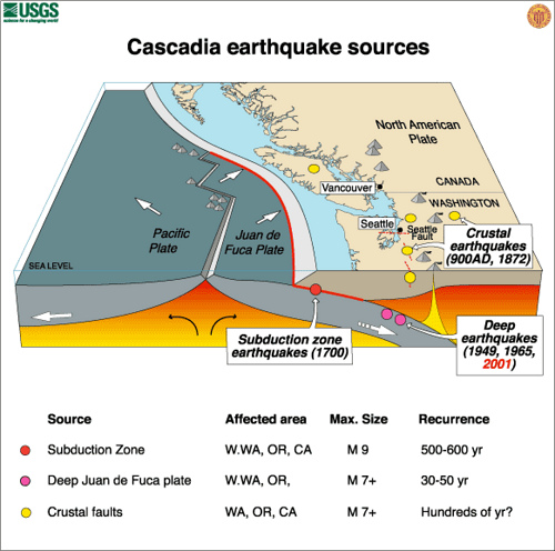
Great Subduction Zone earthquakes are the largest earthquakes in the world, and are the only source zones that can produce earthquakes greater than M8.5. The CSZ has produced magnitude 9.0 or greater earthquakes in the past, and undoubtedly will in the future. The last known megathrust earthquake in the northwest was in January, 1700, just over 300 years ago. Geological evidence indicates that such great earthquakes have occurred at least seven times in the last 3,500 years, a return interval of 400 to 600 years. To learn more about the history of the Cascadia Subduction Zone and the science that led to the discovery of it, delve into land level changes and turbidites created by the CSZ earthquakes. For more about the Cascadia Subduction Zone, visit the USGS webpage discussing this topic.
The CSZ may be unique among the worlds subduction zones in that it produces very few (if any) earthquakes unambiguously on the plate interface. Coupled with evident occurrence of great megathrust earthquakes, the CSZ must be much more strongly locked than other subduction faults. The geological evidence has led to different interpretrations, moreover, about whether the entire CSZ always ruptures in great M9 earthquakes, or whether smaller M8 or M8.5-sized events also can break parts of the zone in between the full rupture events.
This map shows the boundary between the Juan de Fuca Plate system and the North American Plate which forms the Cascadia Subduction Zone. For those unfamiliar, Cascadia, almost more than any other sense, is defined through the geologic dynamicsm of this faultline, taking it’s borders from the watersheds that flow from the edge of the Continental Crust, uplifted by the Cascadia Subduction Zone (also known as the Cascadia fault) as the Juan de Fuca plate slips underneath the North American in a convergent plate boundary that stretches from northern Vancouver Island in Canada to Northern California.
This fault is responsible for deep earthquakes known as Cascadia megaquakes and the active volcanism of the Cascade mountains that has shaped our region for tens of thousands of years. A Cascadia Megaquake refers to large, deep thrust earthquakes along the Cascadia Subduction Zone. The last Cascadia Megaquake occurred January 26, 1700 with an estimated moment magnitude of 8.7–9.2 and stretched from mid-Vancouver Island, south along the Pacific Northwest coast as far as northern California stretching for more than 1,000 kilometers (620 miles), with an average slip of 20 meters (66 ft), and resulted in a massive tsunamai felt as far away as Japan.
Cascadia Megaquakes occur every 300-500 years. These earthquakes are known as megathrust or great earthquakes. They can involve 10 to 20 metres of fault movement, along the hundreds of kilometres that make up the fault line. After a great earthquake, the two plates become locked together again and the stick-slip cycle is repeated.
Much of Cascadian planning and co-operation still relies around increasing the resilience of our communities in the face of large earthquakes above a 9.0 magnitude that could impact the largest population centers in the region, such as Vancouver, Victoria, Seattle and Portland, leading to tsunamis or volcanic eruptions. In the past these have included such notable eruptions as Mount Mazama (Crater Lake) about 7,500 years ago, the Mount Meager massif (Bridge River Vent) about 2,350 years ago, and Mount St. Helens in 1980.
Discovering the Cascadia Faultline and Subduction Zone
There are no contemporaneous written records of the 1700 Cascadia earthquake. Orally transmitted legends from the Olympic Peninsula area tell of an epic battle between a thunderbird and a whale. In 2005, seismologist Ruth Ludwin set out to collect and analyze anecdotes from various First Nations groups. Reports from the Huu-ay-aht,[3] Makah,[3] Hoh,[4] Quileute,[5][4] Yurok,[5] and Duwamish[5] peoples referred to earthquakes and saltwater floods. This collection of data allowed the researchers to come up with an estimated date range for the event; the midpoint was in the year 1701.[3]
In the 1960s, underground fractures were uncovered by oil companies in Puget Sound. These were believed to be inactive through the 1990s.[5]
In the 1980s, geophysicists Tom Heaton and Hiroo Kanamori of Caltech compared the generally quiet Cascadia to more active subduction zones elsewhere in the Ring of Fire. They found similarities to faults in Chile, Alaska, and Japan's Nankai Trough, locations known for megathrust earthquakes, a conclusion that was met with skepticism from other geophysicists at the time.[6]
A 1996 study published by seismologist Kenji Satake supplemented the research by Atwater et al. with tsunami evidence across the Pacific.[3] Japanese annals, which have recorded natural disasters since approximately 600 CE,[1] had reports of a sixteen-foot tsunami that struck the coast of Honshu Island during the Genroku.[6][3] Since no earthquake had been observed to produce it, scholars dubbed it an "orphan tsunami."[1] Translating the Japanese calendar, Satake found the incident had taken place around midnight of 27–28 January 1700, ten hours after the earthquake occurred. The original magnitude 9.0 earthquake in the Pacific Northwest had thus occurred around 9pm local time on 26 January 1700.[1]
Ghost forests

During low tide one day in March 1986, paleogeologist Brian Atwater dug along Neah Bay with a nejiri gama, a small hand hoe. Under a top layer of sand, he uncovered a distinct plant—arrowgrass—that had grown in a layer of marsh soil. This finding was evidence that the ground had suddenly sunk under sea level, causing saltwater to kill the vegetation. The event had happened so quickly that the top layer of sand sealed away the air, thus preserving centuries-old plants.[6]
In 1987, Atwater mounted another expedition paddling up the Copalis River with Dr. David Yamaguchi, who was then studying the eruptions of Mount St. Helens.[6] The pair happened upon a section of "ghost forest," so-called due to the dead, gray stumps left standing after a sudden inundation of salt water had killed them hundreds of years ago.[4] Originally thought to have died slowly due to a gradual rise in sea level,[1] closer inspection yielded a different story: the land plummeted up to two meters during an earthquake.[4] Having initially tested spruce using tree-ring dating, they found that the stumps were too rotted to count all the outer rings. However, upon having examined those of the western red cedar and comparing them to the living specimens meters away from the banks, they were able to approximate their year of death. There were rings up until the year 1699, indicating that the incident had occurred shortly thereafter. Root samples confirmed their conclusion, narrowing the time frame to the winter of 1699 to 1700.[3][6]
As with the arrowgrass site, the banks of the Copalis River are lined with a layer of marsh followed by a layer of sand. Jody Bourgeois and her team went on to demonstrate that the sand cover had originated with a tsunami surge rather than a storm surge.[4]
In 1995, an international team led by Alan Nelson of the USGS further corroborated these findings with 85 new samples from the rest of the Pacific Northwest. All along British Columbia, Washington State, and Oregon, the coast had fallen due to a violent earthquake and been covered by sand from the subsequent tsunami.[6]
A further ghost forest was identified by Gordon Jacoby, a dendrochronologist from Columbia University, 60 feet (18 m) underwater in Lake Washington. Unlike the other trees, these suffered from a landslide rather than a dip in the fault during a separate event around 900 CE.[5]
