
Volcanoes of Cascadia
The Cascadia Mountains are filled with a breathtaking array of beautiful landscapes. One can travel from the beaches of the Pacific Ocean or the Salish Sea and, within sixty minutes, be within high, forested mountain passes. No geographical feature is more impressive than the notable mountain peaks – many of which are still-active volcanoes. On a clear day, the tallest mountains dominating the view are neighboring volcanoes, their glaciated peeks residing above the clouds. Most amazingly, many of these mountains are easily accessible to residents; the drive is short and many hikes suitable of novice and intermediate hikers and climbers. This poster illustrates eight of the region’s most notable mountains. Information about the mountains includes geographical coordinates, elevation, and English and native names.
These volcanoes are part of the Pacific Ring of Fire, a volcanic arc along western North America that extends for more than 1100 km (700 miles) from southwestern British Columbia, through Washington, Oregon and into Northern California, and has resulted from the plate tectonics and lifting of the continental crust of the Cascadia subduction zone. Although taking its name from the Cascade Range, this term is a geologic grouping rather than a geographic one, and the Cascade Volcanoes extend north into the Coast Mountains, past the Fraser River which is the northward limit of the Cascade Range proper.
The Cascade Arc includes nearly 20 major volcanoes, among a total of over 4,000 separate volcanic vents including numerous stratovolcanoes, shield volcanoes, lava domes, and cinder cones. The present day Cascadia volcanoes are young in geological terms, with most of the present-day Cascade less than 2,000,000 years old, and the highest peaks less than 100,000 years old. Twelve volcanoes in the arc are over 10,000 feet (3,000 m) in elevation, and the two highest, Mount Rainier and Mount Shasta, exceed 14,000 feet (4,300 m).
Some of the major cities along the length of the arc include Portland, Seattle, and Vancouver, and the population in the region exceeds 10 million. All could be potentially affected by volcanic activity and great subduction-zone earthquakes along the arc. Because the population of the Pacific Northwest is rapidly increasing, the Cascade volcanoes are some of the most dangerous, due to their eruptive history and potential for future eruptions, and because they are underlain by weak, hydrothermally altered volcanic rocks that are susceptible to failure. Much of Cascadian bioregional and intergovernmental policy research and planning is focused on creating effective emergency response in the face of wildfire, tsunami, earthquake, drought, flooding, and volcanic eruption, as well increasing regional resiliency and independence in the face of such potential disasters.
These Volcanoes have erupted several times in recorded history. Two most recent were Lassen Peak in 1914 to 1921 and a major eruption of Mount St. Helens in 1980. It is also the site of Canada's most recent major eruption about 2,350 years ago at the Mount Meager massif.
Top 10 Volcanoes of Cascadia (by height)
Text descriptions underneath our images and description by Volcanoes of Cascadia. You can purchase wonderful cards or posters of the Volcanoes of Cascadia there.

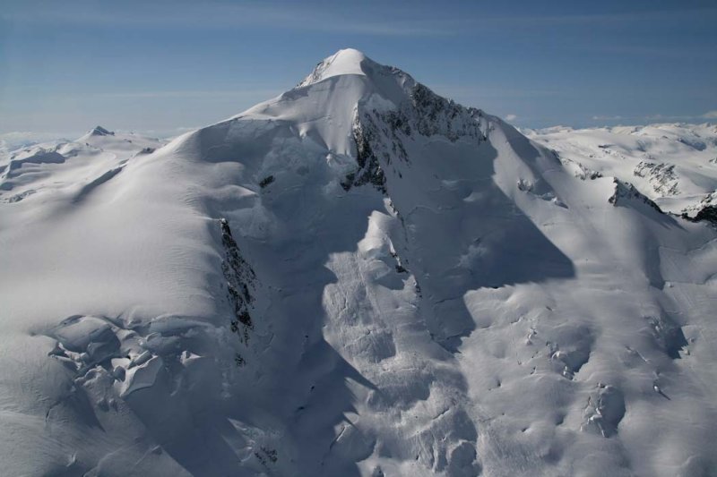
#1 Tahoma (Mt. Rainier)
Elevation: 14,4114 ft / 4,392 m
Indigenous Names: Talol, Tacoma or Pooskaus.
Location: Washington State
Coordinates: 46°51′10″N 121°45′37″W
Last erruption: November to December 1894
Mt. Tahoma, commonly referred to as Mt. Rainier. It is impossible to ignore Mt. Rainier (or Tacoma to the local native people) which dominates the southeastern skyline of Seattle and can be seen from as far away as Vancouver, Canada. The Highest peak in the Cascades, the still-active volcano is home to two volcanic craters, twenty six major glaciers, and the worlds largest glacial cave network.

#2 Karuk: Úytaahkoo (Mt. Shasta)
Elevation: 14,162ft / 4,317m
Location: California
Coordinates: 41°24′33″N 122°11′42″W
Last Eruption: 1786
Standing a hair shorter than Mount Tahoma, Mount Karuk Uytaahkoo and the connected, slightly smaller Shastina rise dramatically from the terrain of northern California. In the lore of the local Klamath tribes, it is said that Skell, the Spirit of the Above-World, came to Earth and alighted on the mountain, called Uytaahkoo (or “White Mountain”.

#3 Pahto (Mt. Adams)
Elevation: 12,280ft / 3,740m
Indigenous Names: Pahto, Paddo, or Klickitat
Location: Washington State
Coordinates: 46°12′09″N 121°29′27″W
Last Eruption: About 950 AD
Because of Mt. Pahto’s flat dome top, it is sometimes confused with the larger Mount Rainier. In the Bridge of the Gods legend of the Klickitat people, it is said that the god Pahto, lost the lover of the maiden Loowit (Mt. St. Helens) to Wy’east (Mt. Hood) and hung his head in shame. Mount Adams is located in Southern Washington and guards the Columbia River. It has long been dormant, but is not considered extinct.

#4 Wy'east (Mt Hood)
Elevation: 11,239ft / 3,426m
Locatoin: Oregon
Coordinates: 45°22′25″N 121°41′45″W
Last Eruption: 1865 to 1866

#5 Kwelshán (Mt Baker)
Elevation: 10,781ft / 3,286m
Location: Washington
Coordinates: 48°46′38″N 121°48′48″W
Last Eruption: September to 6. November 1880

#6 Dakobed
(Glacier Peak)
Elevation: 10,541ft 3,213m
Location: Washington
Coordinates: 48°06′45″N 121°06′50″W
Last Eruption: 1700 ± 100 years

#7 Seekseekqua
(Mt Jefferson)
Elevation: 10,497ft 3,199m
Location: Oregon
Coordinates:: 44°40′27″N 121°47′58″W
Last Eruption: About 9508. AD
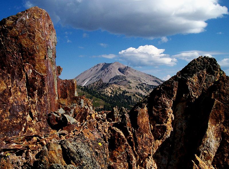
#8 Kohm Yah-mah-nee (Lassen Peak
Elevation: 10,457ft / 3,187m
Location: California
Coordinates: 40°29′17″N 121°30′18″W
Last Eruption: 1914 to 1917
#9 Nch'kay (Mt Silverthrone)
Elevation: 10,370ft / 3,160m
Location: British Columbia
Coordinates: 51°26′00″N 126°18′00″W
Last Eruption: About 100,000 years ago

#10 South Sister
