
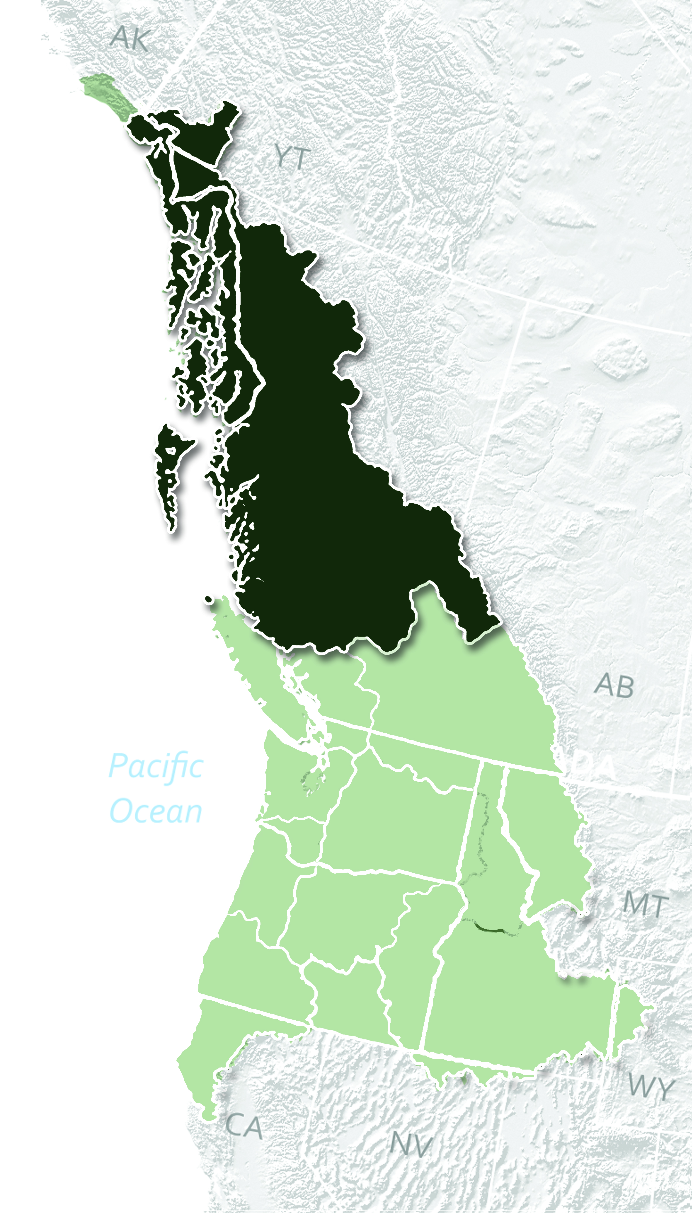
The Nine Regions of Cascadia
Stretching for more than 2500 miles along the Pacific Coast, Cascadia extends as far as the salmon run, and is comprised of 75 distinct ecoregions that spread across an incredible diversity and range of habitats, wilderness and landscapes. These watersheds stretch from South East Alaska to Northern California, and from the crest of the continental divide to the Pacific coast westward. Cascadia is a bioregion defined by the watersheds of the Columbia and Fraser river valleys that stretches from Northern California to south east Alaska and as far east as the Yellowstone Caldera and continental divide. It encompasses most of the states and province of British Columbia, Washington, Oregon and Idaho, and parts of southeast Alaska, Northern California and Montana.
For ease of use, we have shrunk these areas into nine different geographic regions that share similar physical features, watersheds and cultures of the people living within them. The nine regions of Cascadia come from open source GIS data, cartographic explorations of ecoregion and bioregion mapping by David McCloskey and the Cascadia Institute, and simplified for ease of use into broader boundaries. Together, Cascadia currently has a combined population of 18.3 Million.

Cascade plateau
Eastern Washington, Oregon
Introduction: The Cascadia Plateau is located in central Cascadia and is bordered by the Cascade mountains on the east and drains into the Columbia River basin. It was the traditional homeland of the Niimíipuu (Nez Perce), Yakama, Umatilla and confederated tribes of the Warm Springs.
Alternative Name: Columbia Plateau
Approximate Population: 1.96 Million
Largest City: Spokane
Other Notable Cities: Bend, Yakima
Indigenous Groups: Shuswap, Lilloeet, Ntlakapamux, Okanagan, Kutenai, Sandpoil, Kalispel, Spokan, Flathead, Coeur D'Alene, Walla Walla, Yakama, Cowlitz, Klickitat, Cayuse, Nez Perce, Umatilla, Tenino, Molala
Ecoregions Included: Columbia Gorge, Yakama, Palouse, Ochoco/John Day, Snow Cap Plateau, Walla Walla/Umatilla, Deschuts/High Lava Desert
Highest Point: Red Mountain (9,560 feet) in the Wallowas is the highest point in Baker County. A clear day at the top of Marys Peak, at 4,097 feet, affords views to the Pacific Ocean to the west and Cascade peaks to the east, according to the Forest Service.
Notable Features: The Cascadia Plateau is home to the largest fungi in the world - aptly named the ‘Humongous Fungus’ with one honey mushroom estimated to be aged 2200 years old, and covering more than 3.5 square miles in the Malheur National Forest.

E’ lip chuck
(first waters) Cascadia
British Columbia, Idaho, Montana, Washington

The Columbia Mountains are edged by the Continental Divide and are home for the headwaters of both the Fraser and Columbia watersheds.
Alternative Name: Columbia Mountains, Fraser & Columbia Headlands
Approximate Population: 1.20 Million
Largest City: Kelowna
Other Notable Cities: Kamloops, Missoula
Indigenous Groups: Okanagan Nation Alliance, Westbank First Nation, Lower Similkameen Indian Band, Upper Similkameen Indian Band, Osoyoos Indian Band, Penticton Indian Band, Okanagan Indian Band, Upper Nicola Indian Band, Confederated Tribes of the Colville
Ecoregions Included: St. Regis/Bitterroot, Coeur d'Alene/Spokane, Blackfoot/Clark, Fork Flathead, Kutenai/Kalispell, Pend Oreille/Selkirks, Kootenay Lakes/Kokanee, Columbia Plateau, Shuswap/Monashee Highlands, Columbia Icefields, Thompson/Clearwater Highlands, Cariboo/Quesnel Highlands
Highest Point: Mount Sandford Elevation: 3,519 m (11,545 ft). Mount Sandford was first summited by the prodigious mountaineer of the area Howard Palmer. At the turn of the 20th century, after the railroad was finished, more remote ranges such as these Selkirk Mountains in the Columbia range became accessible to climbers. Palmer attempted the summit a dozen times over the course of four years before ultimately hiring climbing guides from Switzerland and succeeding on 9am June 23rd 1912.
Notable Features: Kryptozoologists will rejoice around Lake Okanagan, an inland fjord like waterway purported to have a sea serpent like lake monster called the Ogopogo. Sightings began in 1872 (before the Loch Ness Monster gained notoriety) and have continued over time with video footage captured as recently as 2011. However the legend of the lake began before Ogopogo as, the First Nations of the area also tell of a frightening creature or spirit named Naitaka who lived at the bottom of the lake and threatened those who entered it. Chickens and small animals were taken and dropped overboard when crossing as offerings to Naitaka in hopes of a safe passage.

Ságh-a-lie
(Upper)
Cascadia
British Columbia, Southern Alaska
Alternative Name: Ságh-a-lie Cascadia
Approximate Population: 0.33 Million
Largest City: Prince George
Other Notable Cities: Juneau, Prince Rupert
Ecoregions Included: Kamloops/Nicola Plateau, Fraser Plateau, Chilcotin/Nazka Plateau, Kwakiutl, Anahim/Tweedsmuir, Bella Coola/Coastal Gap, Nechako Plateau, Fraser Basin, Bulkley, Takla-Stuart/Babine Lakes, Lower Skeena Nass, Skeena-Nass, Tlingit Archipelago, Stikine, Iskut Stikine Plateau, Taku, Glacier Bay/Fairweather, Alsek Tatshenshini, Kluane/St. Elias/Yakutat
Indigenous Groups: Tlingit, Nisga'a, Haida, Tsimshian, Gitxsan, Haisla, Heiltsuk, Nuxalk, Wuikinuxv
Highest Point: Mount Logan at 5,959 m (19,551 ft) elevation is bested only by Denali on the continent. Due to active tectonic uplifting, Mount Logan is still rising in height. Before 1992, the exact elevation of Mount Logan was unknown and measurements ranged from 5,959 to 6,050 metres (19,551 to 19,849 ft). In May 1992, a GSC expedition climbed Mount Logan and fixed the current height of 5,959 metres (19,551 ft) using GPS.[5]
Temperatures are extremely low on and near Mount Logan. On the 5,000 m high plateau, air temperature hovers around −45 °C (−49 °F) in the winter and reaches near freezing in summer with the median temperature for the year around −27 °C (−17 °F). Minimal snow melt leads to a significant ice cap, reaching almost 300 m (984 ft) in certain spots.[6]
Notable Features: The 3,600 islands off the North Cascadian coast are known as Xhaaidlagha Gwaayaaior or “Islands at the Boundary of the World” to the indigenous population whose oral history in the area can be traced back 7,000 years. Now shortened to Haida Gwaii or “Land of the Haida,” signs of their once significant extant can be seen in the still standing totems. Numerous totems can be seen all over the islands at now abandoned village sites, like the twenty six examples guarding the once thriving village of Ninstints. Thought to have a lifespan like that of humans, the totems are left to decay and decompose naturally. It is anticipated that most will be gone within the next ten years.

Klamath Mountain
Northern California, Southern Oregon
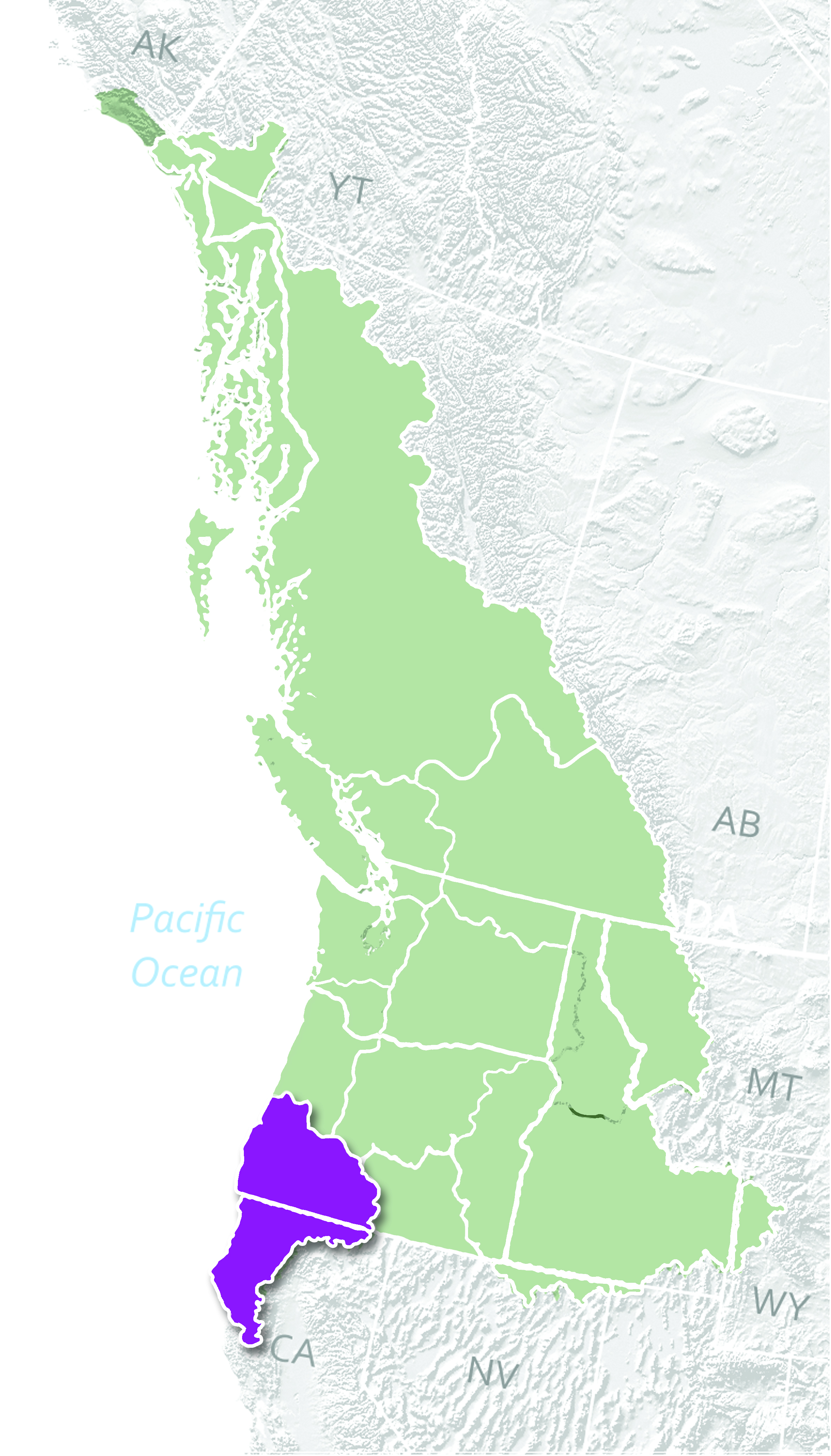
Image from Toward Cascadia, by Ryan Moothart
Alternative Name: West Jefferson
Approximate Population: 0.86 Million
Largest City: Medford
Other Notable Cities: Eureka, Grants Pass
Ecoregions Included: Mendocino/Mattole, Upper Eel, Trinity, Redwood/Humboldt, Siskiyou/Klamath, Shasta, Klamath Lakes/Modoc Rogue/Umpqua, Coos/Coquille
Indigenous Groups: Klamath, Shasta, Takelma, Galice, Applegate, Coquile, Umpqua, Chetko, Tolowa, Tututni, Wiyot
Highest Point: Úytaahkoo or Mount Shasta Elevation: 14,179 ft (4,322 m) “The lore of some of the Klamath Tribes in the area held that Mount Shasta is inhabited by the Spirit of the Above-World, Skell, who descended from heaven to the mountain's summit at the request of a Klamath chief. Skell fought with Spirit of the Below-World, Llao, who resided at Mount Mazama by throwing hot rocks and lava, probably representing the volcanic eruptions at both mountains.”[#]
Notable Features: In the shadow of Úytaahkoo (Mount Shasta), a museum devoted to Sasquatch sits. “The town of Willow Creek is near Bluff Creek, the location where the famous and controversial Patterson-Gimlin video of Bigfoot was originally filmed, spurring the creation of the exhibit. There are casts of footprints, toys, pictures, and videos of the legendary creature. The whole place is guarded by a huge wooden Sasquatch sculpted from a Redwood Tree.
Near the museum, a scenic route can be taken through the Klamath Mountains where the valley views are perfectly reminiscent of the famous Bigfoot video. The Bald Hills Scenic Drive into Redwoods National Park can be easily accessed from Willow Creek, though the road is very windy and sometimes unnerving for those uninitiated to driving through mountainous areas. The views offered in this area are nothing short of spectacular.”

Kee’-kwil-lie
(Lower) Salish Sea
Washington

Image from Toward Cascadia, by Ryan Moothart
Alternative Name: N/A
Approximate Population: 4.79 Million
Largest City: Seattle
Other Notable Cities: Bellevue, Tacoma
Ecoregions Included: Olympic, Chehalis/Willapa, Cowlitz/Lewis, Ish River/Salish Sea
Indigenous Groups: Chinook, Chehalis, Cowlitz , Duwamish, Hoh, Jamestown S'Klallam, Lower Elwha, Makah, Mitchell Bay Band, Muckleshoot, Nisqually, Noo-Wha-Ha Band, Nooksack, Port Gamble Indian Community, Puyallup, Quileute, Quinault, Samish, Sauk-Suiattle, Shoalwater Bay, Skokomish, Snohomish, Snoqualmie, Snoqualmoo, Squaxin Island, Steilacoom, Stillaguamish, Suquamish. Swinomish, Tulalip, Upper Skagit.
Highest Point: Tahoma (Mount Rainier) Elevation: 14,411 ft (4,392 m) Mt. Rainier is considered one of the most dangerous volcanoes in the world, and it is on the Decade Volcano list. Because of its large amount of glacial ice, Mt. Rainier could produce massive lahars that could threaten the entire Puyallup River valley, and poses a grave threat to the southern sections of the 3.7-million-resident Seattle metropolitan area.
Notables: The South Salish region, long known for industry and innovation, claims a number of notable world firsts. The first floating concrete bridge in the world carries the Eastbound lanes of traffic across I5 between Leschi and Mercer Island. KOMO TV was the first to broadcast local television in HD with their daily newscast transitioning to digital high definition in 1999. It is also home to the birthplace of the modern Cascadia movement; Seattle University.
Ságh-a-lie
(upper) Salish coast
British Columbia, Washington

Alternative Name: Fraser Delta
Approximate Population: 3.02 Million
Largest City: Vancouver (BC)
Other Notable Cities: Surrey, Abbotsford, Bellingham
Ecoregions Included: Icefields/Fjordland/Sunshine Coast, Mountain Valleys
Indigenous Groups: Sts'Ailes (Chehalis), Lummi, Musqueam, Katzie/Katzie, Tsawwassen, Semiahmoo, Tsleil-Waututh, Kwikwetlem
Highest Point: Mount Waddington. “From Waddington's 13,186 ft (4,019 m) fang to sea level at the heads of Bute and Knight Inlets is only a few miles; across the 10,000-foot-deep (3,000 m) gorges of the Homathko and the Klinaklini Rivers stand mountains almost as high, and icefields even vaster and whiter, only a few aerial miles away, with a maw deeper than the Grand Canyon, comparable in relief to the Himalayas”
Notable Features: Sasquatch activity, through sightings and research, has been concentrated in the region surrounding [the North Salish Coast’s] Harrison Lake. The area has embraced this association. The town of Harrison Hot Springs held its first Sasquatch Days in 1938. It was a two-day event attended by Indigenous peoples from Canada and the United States. Sasquatch Days were re-launched as an annual celebration in 2012.

Snake River
Oregon, Idaho, Nevada

Image from Toward Cascadia, by Ryan Moothart
Snake River
Alternative Name: Southeast Cascadia
Approximate Population: 1.37 Million
Largest City: Boise
Other Notable Cities: Idaho Falls, Pocatello
Ecoregions Included:
Indigenous Groups: Bannock, Coeur d'Alene tribe, Interior Salish, Ktunaxa, Nez Perce, Paiute, Shoshone
Highest Point: Borah Peak. Elevation: 12,662 ft (3,859m) In the constant grinding subduction of the Cascadia Plate under the Pacific plate, movement, in the shape of earthquakes, is common. In 1983 an earthquake underneath Borah Peak lifted the mountain by 30 centimeters (a foot), while the valley it sits in fell 2.4 meters.
Notable Feature: Back to volcanic points of interest, Craters of the Moon National Park offers visitors a look at the deepest rift on earth measuring some 800 feet deep. It was created when volcanic lava flows met groundwater some 2,200 years ago and exploded, fracturing the earth.

Vancouver island
British Columbia

Alternative Name: N/A
Approximate Population: 0.74 Million
Largest City: Victoria
Other Notable Cities: Nanaimo, Port Alberni, Parksville, Courtenay, and Campbell River.
Indigenous Groups: Kwakwaka'wakw, Nuu-chah-nulth, Coast Salish
Ecoregions Included: Georgia Straight, West Coast
Highest Point: Golden Hinde. Elevation: 2,195 m (7,201 ft) The mountain is also affectionately known by its alternative name "The Rooster's Comb", conferred by early alpinists because of the mountain's appearance.
Notable Feature: Canada’s second largest Douglas Fir now stands alone in a field, the rest of her neighbors being clear cut. “Despite the region’s booming logging industry (a staggering 99 percent of the old-growth Douglas firs in British Colombia have been cut down) a logger spared Big Lonely Doug from being felled in 2012. No one is quite sure why this particular mature tree was saved. Big Lonely Doug still stands tall, now a sad but majestic symbol of the disappearing old-growth forests of British Colombia, and the ongoing fight to save them.”

Willamette valley
Oregon, Washington

Alternative Name: N/A
Approximate Population: 2.95 Million
Largest City: Portland
Other Notable Cities: Eugene, Salem, Vancouver
Ecoregions Included: Chinook/Tillamook, Siuslaw/Dunes and Lakes, Alsea/Siletez, Willamette
Indigenous Groups: Burns Paiute, Celilio-Wyam, Chetco, Clatsop-Nehalem, Siletz, Coos/Lower Umpqua/Siuslaw Indians, Grand Ronde, Umatilla, Warm Springs, Rogue/Table Rock/Associated Tribes, Coquille, Cow Creek Band of Umpqua Tribe, Klamath, Northwest Cherokee Deer Clan, Northwest Cherokee Wolf and Paint Clan, Northwest Cherokee Wolf Band of the Southeastern Cherokee Confederacy,Tchinouk Indians, The Cherokee Delaware Tribe of the Northwest, Tolowa-Tututni
Highest Point: Wy'east or Mount Hood Elevation: 11,249 ft (3,429 m) Wy’east features prominently in the history of native tribes who tell a story of how the volcano came to be. Two sons of the Great Spirit Sahale named Wy’east and Pahto were both in love with the same woman Loowit. They battled for her attention by shaking the ground and burning the forests. Enraged by their contest, Sahale immortalized the three spirits by turning them into mountains. He made beautiful Mount St. Helens for Loowit, proud and erect Mount Hood for Wy'east, and the somber Mount Adams for the mourning Pahto.
Notable Feature: Millennia of volcanic eruptions continue to terraform the surface of Cascadia with destructive yet dazzling results, such as in Crater lake, the deepest lake on the continent. Yet water has a great influence too. The largest Ocean Cave can also be found in Cascadia on the Oregon Coast. It serves as the only mainland rookery of the Stellar Sea Lion, and plethora of wildlife including Eagles, Puffins, Orcas and Blue Whales can be seen there in season.
